Climate in New Mexico
New Mexico, fifth largest State in the Union, with a total area of 121,412 square miles, is approximately 350 miles square, and lies mostly between latitudes 32° and 37° and longitudes 103° and 109° W. The State's topography consists mainly of high plateaus or mesas, with numerous mountain ranges, canyons, valleys, and normally dry arroyos. Average elevation is about 4,700 feet above sea level. The lowest point is just above the Red Bluff Reservoir at 2,817 feet where the Pecos River flows into Texas. The highest point is Wheeler Peak at 13,161 feet. The principal sources of moisture for the scant rains and snows that fall on the State are the Pacific Ocean, 500 miles to the west, and the Gulf of Mexico, 500 miles to the southeast. New Mexico has a mild, arid or semiarid, continental climate characterized by light precipitation totals, abundant sunshine, low relative humidities, and a relatively large annual and diurnal temperature range. The highest mountains have climate characteristics common to the Rocky Mountains.
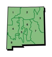
The State is divided into three major areas by mountain ranges and highlands, oriented in a general north-south direction, which merge in the north. The Northern Mountain and Central Highlands, between longitudes 105° and 106° W, are the western boundary of the Northeastern and Southeastern Plains which slope gradually eastward and southeastward. The northern part of these eastern plains lies within the Arkansas River Basin and is drained mostly by the Canadian River, which flows southward then eastward into Oklahoma to its confluence with the Arkansas, and the Cimarron River in the extreme northeastern corner. The Pecos River rises in the Sangre de Cristo Mountains and flows southward through the Southeastern Plains into Texas, and then southeastward to join the Rio Grande. West of the mountain ranges that form the Continental Divide, whose height decreases to a markedly lower elevation in southern New Mexico, rivers drain into the Gulf of California through the Colorado River system. Principal tributaries flowing westward into the Colorado River are the San Juan River in the north, the Gila River in the south, and the San Francisco tributary in the north, the Gila River in the south, and the San Francisco tributary of the Gila and other headwater streams of the Little Colorado River in the west-central area. The largest closed basins in the west are the Plains of St. Augustine in Catron County and the Rio Membres Basin in Grant and Luna Counties. Between the Northern Mountains and the Central Highland system and the Continental Divide system is the Rio Grande Valley which widens toward the south. The Rio Grande rises in the San Juan Mountains of southern Colorado, flows southward through New Mexico, then southeastward along the Texas-Mexico border into the Gulf of Mexico. The closed Tularosa Basin in southern New Mexico is in an intermountain area of the Central Valley. The state is divided into 8 climate divisions based on the state topographic features in the following image.
Temperature
Mean annual temperatures range from 64° F in the extreme southeast (Division 1) to 40° F or lower in high mountains and valleys of the north (division 2); elevation is a greater factor in determining the temperature of any specific locality than its latitude. This is shown by only a 3° F difference in mean temperature between stations at similar elevations, one in the extreme northeast and the other in the extreme southwest; however, at two stations only 15 miles apart, but differing in elevation by 4,700 feet, the mean annual temperatures are 61° and 45° F - a difference of 16° F or a little more than 3° decrease in temperature for each 1,000 foot increase in elevation.
During the summer months, individual daytime temperatures quite often exceed 100° F at elevations below 5,000 feet (division 8); but the average monthly maximum temperatures during July, the warmest month, range from slightly above 90° F at the lower elevations to the upper 70's at high elevations. Warmest days quite often occur in June before the thunderstorm season sets in during July and August, afternoon convective storms tend to decrease solar insolation, lowering temperatures before they reach their potential daily high. The highest temperatures of record in New Mexico are 116° at Orogrande on July 14, 1934, and at Artesia on June 29, 1918. A preponderance of clear skies and low relative humidities permit rapid cooling by radiation from the earth after sundown; consequently, nights are usually comfortable in summer. The average range between daily high and low temperatures is from 25° to 35° F.
In January, the coldest month, average daytime temperatures range form the middle 50s in the southern and central valleys to the middle 30s in the higher elevations of the north. Minimum temperatures below freezing are common in all sections of the State during the winter, but subzero temperatures are rare except in the mountains. The lowest temperature recorded at regular observing stations in the State was -50° F at Gavilan on February 1, 1951. An unofficial low temperature of -57° F at Ciniza on January 13, 1963, was widely reported by the press.
The freeze-free season ranges from more than 200 days in the southern valleys to less than 80 days in the northern mountains where some high mountain valleys have freezes in summer months.
Precipitation
Average annual precipitation ranges from less than 10 inches over much of the southern desert and the Rio Grande and San Juan Valleys to more than 20 inches at higher elevations in the State. A wide variation in annual totals is characteristic of arid and semiarid climates as illustrated by annual extremes of 2.95 and 33.94 inches at Carlsbad during a period of more than 71 years. Average rainfall over the state has little meaning but is 13.9 inches based on the Cooperative Observer Network of rain gages.
Summer rains fall almost entirely during brief, but frequently intense thunderstorms. The general southeasterly circulation from the Gulf of Mexico brings moisture for these storms into the State, and strong surface heating combined with orographic lifting as the air moves over higher terrain causes air currents and condensation. July and August are the rainiest months over most of the State, with from 30 to 40 percent of the year's total moisture falling at that time. The San Juan Valley area is least affected by this summer circulation, receiving about 25 percent of its annual rainfall during July and August. During the warmest 6 months of the year, May through October, total precipitation averages from 60 percent of the annual total in the Northwestern Plateau to 80 percent of the annual total in the eastern plains.
Winter precipitation is caused mainly by frontal activity associated with the general movement of Pacific Ocean storms across the country from west to east. As these storms move inland, much of the moisture is precipitated over the coastal and inland mountain ranges of California, Nevada, Arizona, and Utah. Much of the remaining moisture falls on the western slope of the Continental Divide and over northern and high central mountain ranges. Winter is the driest season in New Mexico except for the portion west of the Continental Divide. This dryness is most noticeable in the Central Valley and on eastern slopes of the mountains.
Much of the winter precipitation falls as snow in the mountain areas, but it may occur as either rain or snow in the valleys. Average annual snowfall ranges from about 3 inches at the Southern Desert and Southeastern Plains stations to well over 100 inches at Northern Mountain stations. It may exceed 300 inches in the highest mountains of the north.
Floods
General floods are seldom widespread in New Mexico. Heavy summer thunderstorms may bring several inches of rain to small areas in a short time. Because of the rough terrain and sparse vegetation in many areas, runoffs from these storms frequently cause local flash floods. Normally dry arroyos may overflow their banks for several hours, halting traffic where water crosses highways; damaging bridges, culverts, and roadways; and if in an urban area, possible causing considerable property damage. Snowmelt during April to June, especially in combination with a warm rain, and heavy general rains during August to October may occasionally cause flooding of the larger rivers. Although streams in New Mexico have risen substantially during several floods, the overflows cannot be termed disastrous because comparatively little real property damage has resulted in this lightly industrialized and sparsely populated State. During spring snowmelt, main rivers may exceed flood stage and cause some damage to property along their banks.
Severe Storms
On rare occasions, a tropical hurricane may cause heavy rain in eastern and central New Mexico as it moves inland from the western part of the Gulf of Mexico, but there is no record of serious wind damage from these storms. Also on rare occasions, a tropical storm moving inland from the Gulf of California area may cause heavy rain in southwestern New Mexico.
Tornadoes are occasionally reported in New Mexico, most frequently during afternoon and early evening hours from May through August. There is an average of nine tornadoes a year, but damage has been light because most occur over open, sparsely populated country. The tornado causing the most loss of life and injuries occurred in 1930 at Wagon Mound with 3 deaths, 19 injuries, and property loss of $150,000. Greater property damage, $450,000, but fewer casualties-1 death and 8 injuries - resulted from a destructive tornado at Maxwell in 1964.
Thunderstorms are relatively frequent in summer, averaging from 40 in the south to more than 70 in the northeast, the latter area having the second greatest thunderstorm frequency in the country. Occasionally, these heavy thunderstorms are accompanied by hail, with the greatest hail frequency occurring near and to the east of Los Alamos. When hail falls over an agricultural area, considerable local crop damage may result.
Sunshine
Plentiful sunshine occurs in New Mexico, with from 75 to 80 percent of the possible sunshine being received. In winter, this is particularly noticeable with from 70 to 75 percent of the possible sunshine being received. It is not uncommon for as much as 90 percent of the possible sunshine to occur in November and in some of the spring months. The average number of hours of annual sunshine ranges from near 3,700 in the southwest to 2,800 in the north-central portions.
Relative Humidity
Average relative humidities are lower in the valleys but higher in the mountains because of the lower mountain temperatures. Relative humidity ranges from an average of near 65 percent about sunrise to near 30 percent in midafternoon; however, afternoon humidities in warmer months are often less than 20 percent and occasionally may go as low as 4 percent. The low relative humidities during periods of extreme temperatures ease the effect of summer and winter temperature.
Wind
Wind speeds over the State are usually moderate, although relatively strong winds often accompany occasional frontal activity during late winter and spring months and sometimes occur just in advance of thunderstorms. Frontal winds may exceed 30 mph for several hours and reach peak speeds of more than 50 mph. Spring is the windy season. Blowing dust and serious soil erosion of unprotected fields may be a problem during dry spells. Winds are generally stronger in the eastern plains than in other parts of the State. Winds generally predominate from the southeast i9n summer and from the west in winter, but local surface wind directions will vary greatly because of local topography and mountain and valley breezes.
Evaporation
Potential evaporation in New Mexico is much greater than average annual precipitation. Evaporation from a Class A pan ranges from near 56 inches in the north-central mountains to more than 110 inches in southeastern valleys. During the warm months, May through October, evaporation ranges from near 41 inches in the north-central to 73 inches in the southeast portions of the State.
Drought
Periods of recent extreme meterorological drought, as defined by a Palmer drought index of -4.0 or lower, have been noted in the mid-1930's in the Northeastern Plains and Central Highlands, in 1947 in the Central Highlands, in the 1950's throughout the State, in 1963-64 in the Northern Mountains, in 1964 in the Southeastern Plains, and in 1967 in the Northern Mountains. At drought started in 2000 and continued till 2004. The longest general drought since 1930 was in the 1950's.
Hydrologic drought is when surface water supplies are low as defined by the surface water supply index (SWSI) which is scaled the same at the Palmer drought index from +4 to -4. The SWSI uses information about stream flow and reservoir storage in its calculation. Even when the Palmer drought index becomes positive the SWSI can remain negative as has occurred in New Mexico in 2004.
Recreation and Health
Large primitive areas and many campgrounds are in the more than 8 million acres of forestland. There are many National Monuments and State Parks and one National Park: Carlsbad Caverns. Hunting and fishing areas are available in most sections of the State, and several reservoirs have facilities for boating. Snows in mountain areas permit skiing during winter months. These features, combined with generally mild, dry, sunny climate, make New Mexico a mecca for outdoor recreation. Many people seeking a mild and ry climate for health reasons find the State a desirable place to settle.
Climate and the Economy
Principal industries of New Mexico are agriculture, mining, lumbering, gas and oil production, and recreation. Of these, the influence of climate upon agriculture and recreation is of major importance. Less than 4 percent of the State's area is under cultivation, and about one-third of this area is irrigated. Farming on this latter portion is intensive. More than one-half of the area of the State is pastureland; about 28 percent is woodland. The remainder is generally classified as wasteland and urban. Most irrigated land is in the southern valleys, although some is found in the middle Rio Grande Valley, the Canadian Valley in the northeast, the San Juan Valley in the northwest, and in east-central counties. These irrigated lands draw on stored surface water as well as underground water supplies for irrigation. Most dryland farming is in the eastern plains, but short-season dryland summer crops are grown in some small areas in the Central Highlands. Dryland crops are divided primarily between winter grains, which require favorable moisture conditions from early fall throughout winter and spring, and short-season row and feed crops, which depend mainly on summer showers to produce a yield. Stored surface water for irrigation, used principally for cotton, truck and feed crops, and fruit and nuts, depends on adequate winter snows in the mountains of both the northern part of the State and in southern Colorado for its initial source. Livestock raising is the most extensive agricultural pursuit. Sufficient moisture usually falls, providing for the growth of good range forage. Because of the mild climate, livestock can live on the open range throughout the year, grazing in the higher mountain ranges during the summer and in the lower valleys and plains during the winter.
Source: WRCC